22%
of drivers reported difficulty finding correct delivery points
The research, design decisions, and outcomes in this case study reflect my work at Amazon. The case study itself was built by me using Claude as a coding assistant — a deliberate choice to present my work in a custom, coded format rather than a template.
Redesigning how Customer Service Associates submit delivery point corrections inside Amazon's contact center — reducing handling time by 45% and improving delivery success for millions of last-mile packages.
Amazon delivery drivers navigate 21.4 million support contacts per year. A significant portion stem from a single, solvable issue: inaccurate map data. When a geocode is wrong, drivers can't find the delivery point, customers don't receive packages, and Customer Service Associates (CSAs) spend nearly 9 minutes manually correcting data across legacy tools.
As part of Amazon's SDS 3.0 redesign, I led UX for the geocode correction workflow — a new native experience inside AC3 LMS that replaced a fragmented, error-prone process with a guided, intelligent workflow.
Amazon Flex drivers and Delivery Associates operate in the real world — where new developments open, access points change, and map data lags reality. When a geocode is wrong, the driver calls support. But the CSA's experience wasn't much better than the driver's.
"CSAs were toggling between the legacy Driver Contact Landing Page, external mapping tools, and SIM ticketing — all to complete a single correction. The process was error-prone, slow, and untrained associates got it wrong constantly."
The downstream effects were measurable:
I was the UX designer for the geocode correction workflow (Epic 6.0) within Milestone 3 of the SDS 3.0 roadmap — working embedded with product, process engineering, program management, and engineering.
My work spanned the full design lifecycle: from shadowing CSA sessions and translating complex SOPs into intuitive workflows, to delivering high-fidelity mocks and facilitating reviews with SDS leadership.
Mapped current-state workflows with process engineering. Audited legacy DCLP and identified failure points.
Observed 45 CSA interviews and 30 usability sessions. Identified where CSAs deviated from SOP and why.
Translated dense SOP requirements into guided, branching AC3 LMS workflows with interactive prototypes.
Facilitated UAT with 100+ CSAs across global marketplaces before August 2025 worldwide launch.
The geocode correction workflow serves two distinct users with different mental models, technical proficiency, and time pressure. Getting the balance right was critical.
5+ years. High technical proficiency. Trains new CSAs and handles complex cases.
3 months. Learning systems. Follows strict protocols and seeks guidance at each step.
2 years, urban route specialist. Time-pressured and frustrated when the map is wrong.
The geocode correction workflow required balancing SOP compliance, CSA efficiency, and driver experience. Four decisions defined the design.
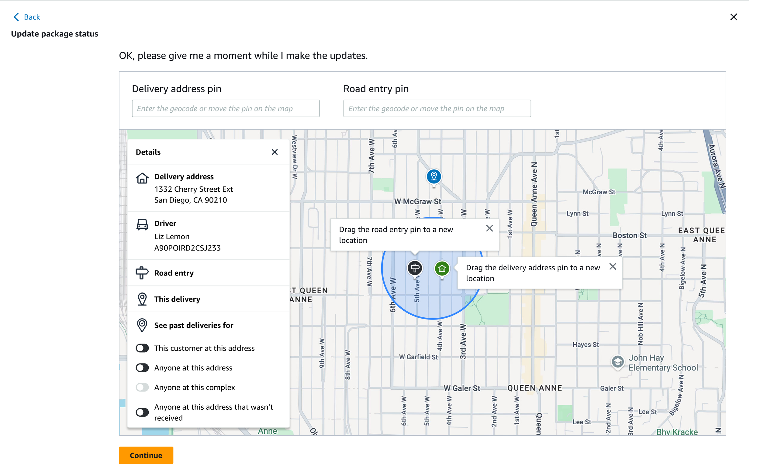
The legacy DCLP required CSAs to reposition both the road entry pin and the delivery point pin — even when only one was incorrect. This caused erroneous corrections and confused CSAs about what they were actually changing.
I designed the new workflow so AC3 does not require moving a pin unless the CSA actually needs to. Each pin is independently optional with its own contextual question set.
Corrections under 25 meters are statistically less likely to reflect a genuine map error — they often indicate a driver preference. Submitting these without scrutiny added noise to the LMAQ review queue.
I introduced a warning gate for sub-25m moves that prompts the CSA to select a reason. This flows directly to LMAQ, reducing false corrections and giving the team structured context.
CSAs kept drivers on the phone while submitting corrections. Submissions could take several minutes, inflating AHT and frustrating drivers with remaining deliveries.
I designed the workflow to guide CSAs to disconnect the driver before submitting. After-call work is deferred to the end. The driver gets back on the road faster; the CSA submits without time pressure.
When an address already has a pending geocode correction in the LMAQ queue, submitting another created duplicate tickets that slowed review and could result in conflicting data.
AC3 now checks for pending corrections before the CSA begins. If one exists, the workflow surfaces it, blocks a new submission, and ends gracefully.
The geocode correction workflow launched globally in August 2025 as part of the Milestones 1–3 release. Results measured against legacy DCLP baseline.
This project stretched across multiple milestones, global marketplaces, and a dense web of stakeholders. A few things I'd carry forward:
The geocode correction workflow in its current form is guided and SOP-compliant. The roadmap points toward a smarter system: ML-powered suggestion engines that surface likely corrections before the CSA has to search, predictive geocode recommendations based on historical delivery patterns, and real-time validation against live map data.
The data instrumentation built into this milestone — structured reasons, pin coordinates, geofence context — is the foundation that makes those future capabilities possible.